Background
One of the important applications of satellite image processing is in disaster management, that is, monitoring natural disasters like earthquakes, hurricanes, tropical cyclones, and floods, and then assessing the damages. It helps federal emergency agencies and disaster relief organizations to strategically plan and control disasters as and when they occur.
Satellite image processing at the edge can create efficacies in processing the data in space, reducing the quantum of data exchange between satellites and ground stations, and reducing the latency between data acquisition, insights generation, and responses to manage the damages.
Solution
In collaboration with Accenture*, Intel developed a structural damage assessment AI reference kit, which may assist you with model quantization to speed up the images' segmentation process on CPU-based computing platforms, while maintaining the ideal FPS (for image segmentation applications). This solution helps to realize a cost-effective option for low-power computing platforms on satellites and maintaining the accuracy level of the prediction like a regular floating-point model.
End-to-End Flow Using Intel® AI Software Products

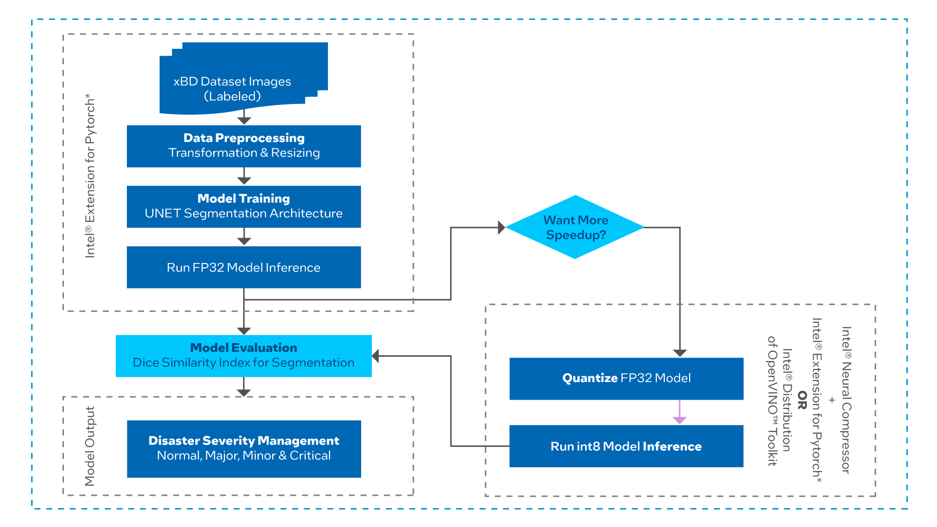
U-Net architecture has been used on the images captured by satellites to assess the severity of structural destruction caused by the disaster. The extent of damage in the buildings is categorized into four groups: normal (no damage), minor damage, major damage, and critical (fully destroyed).
When deploying this model on edge devices with fewer computing and memory resources, the experiment applies further quantization and compression to the model while keeping the same level of accuracy showing a more efficient utilization of underlying computing resources.
This reference kit includes:
- Training data
- An open source, trained model
- Libraries
- User guides
- Intel® AI software products
At a Glance
- Industry: Insurance, government, aerospace, and defense
- Task: Segment the buildings from the satellite-captured images of the disaster area and assess the severity of structural damage to put in the defined category
- Dataset: Annotated high-resolution satellite imagery for assessing building damage
- Type of Learning: Instance segmentation-based transfer learning
- Models: Instance-based UNET CNN model
- Output: Damage assessment in four categories: normal, minor damage, major damage, and critical
- Intel AI Software Products:
- Intel® Extension for PyTorch* v1.13.0
- Intel® Neural Compressor
- Intel® Distribution of OpenVINO™ toolkit
Technology
Optimized with Intel AI Software Products for Better Performance
The structural damage assessment model was optimized with Intel Extension for PyTorch (v1.13.0). Intel Neural Compressor is used to quantize the FP32 model to the int8 model. Intel Distribution of OpenVINO toolkit facilitates the optimization of a deep learning model from a framework and deployment using an inference engine on computing platforms that are based on Intel hardware accelerators.
Intel Extension for PyTorch and Intel Neural Compressor allow you to reuse your model development code with minimal code changes for training and inferencing.
Performance benchmark tests were run on Microsoft Azure* Standard_D8_v5 using 3rd generation Intel® Xeon® processors to optimize the solution.
Benefits
AI-based solutions for satellite image processing have great potential in disaster management and response. Satellite image processing at the edge can create efficacies in processing the data in space, reducing the quantum of data exchange between satellites and ground stations, and reducing the latency between data acquisition, insights generation, and response.
This AI reference kit demonstrates the implementation of a performance-optimized approach for developing an optimal instance image segmentation model that can be used in satellite image processing to evaluate the images for disaster severity assessment.
Machine learning developers may need to train models for a substantial number of datasets. The ability to accelerate training may allow them to train more frequently and achieve better accuracy. Faster inferencing speed may enable them to run prediction in real time as well as offline batch processing.
With Intel® oneAPI components, little to no code change is required to attain the performance boost.